ArcGIS Server Flex API接入百度地图
分享
-
2014-05-17
本实例只是个人兴趣研究,如果想要应用到商业用途,请联系相关厂家)
ArcGIS Server Flex API接入百度地图,是基于地图切片访问原理进行加载,需要ArcGIS Server Flex API重写TiledMapServiceLayer类,接入的地图包括矢量图、交通的POI点及影像图,实现代码如下:
接入矢量地图:
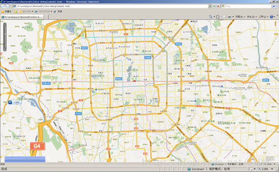
接入混合模式地图:

文章来源:http://blog.csdn.net/sydbc/article/details/17021771
ArcGIS Server Flex API接入百度地图,是基于地图切片访问原理进行加载,需要ArcGIS Server Flex API重写TiledMapServiceLayer类,接入的地图包括矢量图、交通的POI点及影像图,实现代码如下:
package com.esri.viewer.components.common.baidu

{


    import com.esri.ags.SpatialReference;

    import com.esri.ags.geometry.Extent;

    import com.esri.ags.geometry.MapPoint;

    importcom.esri.ags.layers.TiledMapServiceLayer;

    importcom.esri.ags.layers.supportClasses.LOD;

    import com.esri.ags.layers.supportClasses.TileInfo;


    import flash.net.URLRequest;


    import flashx.textLayout.formats.Float;


    public class BaiduTiledMapServiceLayerextends TiledMapServiceLayer

    {

        //成员变量

        private var_tileInfo:TileInfo = new TileInfo(); // see buildTileInfo()

        private var _wkid:int= 102100;//102113;//102100;

        private varcornerCoordinate:Number = 20037508.3427892;

        private var_mapType:String = “Map”;


        public functionBaiduTiledMapServiceLayer()

        {

           super();


           buildTileInfo(); // to create our hardcoded tileInfo


           setLoaded(true); // Map will only use loaded layers

        }


        //———————————-

        //  全屏范围

        //  – requiredto calculate the tiles to use

        //———————————-

        override publicfunction get fullExtent():Extent

        {

          return new Extent(-cornerCoordinate, -cornerCoordinate, cornerCoordinate,cornerCoordinate, new SpatialReference(_wkid));

        }


        //———————————-

        //  初始化范围

        //  – needed ifMap doesn”t have an extent

        //———————————-


        override publicfunction get initialExtent():Extent

        {

          return new Extent(-cornerCoordinate, -cornerCoordinate, cornerCoordinate,cornerCoordinate, new SpatialReference(_wkid));

        }


        //———————————-

        //  空间参考系

        //  – needed ifMap doesn”t have a spatialReference

        //———————————-

        override publicfunction get spatialReference():SpatialReference

        {

           return new SpatialReference(_wkid);

        }


        //———————————-

        //  tileInfo

        //———————————-

        override publicfunction get tileInfo():TileInfo

        {

           return _tileInfo;

        }


        public function setmapType(strMapType:String):void

        {

           this._mapType = strMapType;

        }


        public function getmapType():String

        {

           return this._mapType;

        }


        //———————————-

        //  units

        //  – needed ifMap doesn”t have it set

        //———————————-

        /*

        override publicfunction get units():String

        {

        return“esriDecimalDegrees”;

        }//*/


       //————————————————————————–

        //

        //  关键方法,用于读取服务器上的缓存图片

       //      getTileURL(level:Number, row:Number,col:Number):URLRequest

        //

       //————————————————————————–

        override protectedfunction getTileURL(level:Number, row:Number, col:Number):URLRequest

        {

           var zoom:int = level – 1;

           var offsetX:int = Math.pow(2, zoom) as int;

           var offsetY:int = offsetX – 1;


           var numX:int = col – offsetX;

           var numY:int = (-row) + offsetY;


           zoom = level + 1;

           var num:int = (col + row) % 8 + 1;


           var url:String = null;

           if (mapType == “Map”)

           {

               url = “http://q” + num + “.baidu.com/it/u=x=” + numX + “;y=” + numY + “;z=” +zoom + “;v=009;type=web&fm=44″;

           }

           else if (mapType == “Image”)

           {

               url = “http://q”+num+”.baidu.com/it/u=x=”+numX+”;y=”+numY+”;z=”+zoom+”;v=009;type=sate&fm=46″;

           }

           else if (mapType == “POI”)

           {

               url =“http://q”+num+”.baidu.com/it/u=x=”+numX+”;y=”+numY+”;z=”+zoom+”;v=009;type=trans&fm=47″;

           }


           return new URLRequest(url);

        }


       //————————————————————————–

        //

        //  自定义方法,定义地图缩放等级

        //

       //————————————————————————–

        private functionbuildTileInfo():void

        {

           _tileInfo.height=256;

           _tileInfo.width=256;

           _tileInfo.origin=new MapPoint(-cornerCoordinate, cornerCoordinate);

           _tileInfo.spatialReference=new SpatialReference(_wkid);


           _tileInfo.lods = [

               new LOD(0, 156543.033928, 591657527.591555),

               new LOD(1, 78271.5169639999, 295828763.795777),

               new LOD(2, 39135.7584820001, 147914381.897889),

               new LOD(3, 19567.8792409999, 73957190.948944),

               new LOD(4, 9783.93962049996, 36978595.474472),

               new LOD(5, 4891.96981024998, 18489297.737236),

               new LOD(6, 2445.98490512499, 9244648.868618),

               new LOD(7, 1222.99245256249, 4622324.434309),

               new LOD(8, 611.49622628138, 2311162.217155),

               new LOD(9, 305.748113140558, 1155581.108577),

               new LOD(10, 152.874056570411, 577790.554289),

               new LOD(11, 76.4370282850732, 288895.277144),

               new LOD(12, 38.2185141425366, 144447.638572),

               new LOD(13, 19.1092570712683, 72223.819286),

               new LOD(14, 9.55462853563415, 36111.909643),

               new LOD(15, 4.77731426794937, 18055.954822),

               new LOD(16, 2.38865713397468, 9027.977411),

               new LOD(17, 1.19432856685505, 4513.988705),

               new LOD(18, 0.597164283559817, 2256.994353),

               new LOD(19, 0.298582141647617, 1128.497176)

           ];

        }

    }


}
接入矢量地图:
接入混合模式地图:
文章来源:http://blog.csdn.net/sydbc/article/details/17021771