
ENVI 5.2光谱指数工具(Spectral Indices)
分享
-
2016-06-22
ENVI5.2新增光谱指数工具(Spectral Indices)来计算各种指数,包括植被、地质、人造特性,燃烧区域,和水;同时包括之前版本27种的植被指数与植被指数计算器。
1、新增指数列表
2、特征指数
3、ENVI 5.2波谱指数计算
利用 Spectral Indices 工具计算一个影像的波谱指数,可通过以下步骤实现:

5.勾选Preview ,查看其计算的指数数据,在满足条件的情况下,点击 OK 执行指数计算。

6.选择Display result 选项,计算完后的影像文件自动添加在左侧列表中显示。
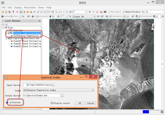
7.点击 OK ,完成植被指数计算。
4、ENVI QuerySpectralIndices API
使用ENVI QuerySpectralIndices API程序可以计算给定影像可获取的指数数据。编写IDL脚本计算光谱指数可参考以下示例编程:
文章来源:http://blog.sina.com.cn/s/blog_764b1e9d0102vaul.html
1、新增指数列表
- Difference Vegetation Index 差异植被指数
- Global Environmental Monitoring Index 全球环境监测指数
- Green Atmospherically Resistant Index 绿度气压阻抗指数
- Green Difference Vegetation Index 绿度指数
- Green Normalized Difference Vegetation Index 绿度归一化植被指数
- Green Ratio Vegetation Index 绿度比值植被指数
- Green Vegetation Index 绿度植被指数
- Infrared Percentage Vegetation Index 红外百分比指数
- Leaf Area Index 叶面积指数
- Modified Chlorophyll Absorption Ratio Index 改进叶绿素吸收比值指数
- Modified Chlorophyll Absorption Ratio Index - Improved 改进 叶绿素吸收比值指数(增强)
- Modified Non-Linear Index 改进 非线性指数
- Modified Simple Ratio 改进 简单比值指数
- Modified Triangular Vegetation Index 改进 三角植被指数
- Modified Triangular Vegetation Index - Improved 改进 三角植被指数(增强)
- Non-Linear Index 非线性指数
- Normalized Difference Water Index 归一化水体指数
- Normalized Multi-band Drought Index 归一化多波段干旱指数
- Optimized Soil Adjusted Vegetation Index 最佳土壤调整植被指数
- Red Green Ratio Index 红绿波段比值指数
- Renormalized Difference Vegetation Index 调整差异植被指数
- Soil Adjusted Vegetation Index 土壤调整植被指数
- Simple Ratio 单一比值指数
- Transformed Chlorophyll Absorption Reflectance Index 转换叶绿素吸收反射比指数
- Transformed Difference Vegetation Index 转换差异植被指数
- Triangular Vegetation Index 三角植被指数
- Visible Atmospherically Resistant Index 可视化气压阻抗指数
- WorldView Improved Vegetative Index (WV-VI) WV改进植被指数
2、特征指数
- Burn Area Index 燃烧面积指数
- Clay Minerals Ratio 黏土矿物比值指数
- Ferrous Minerals Ratio 铁矿比值指数
- Iron Oxide Ratio 氧化铁比值指数
- Normalized Burn Ratio 归一化燃烧比值指数
- Normalized Burn Ratio Thermal 1
- Normalized Difference Built-Up Index 归一化建筑物指数
- Normalized Difference Snow Index 归一化雪盖指数
- WorldView Built-Up Index WV 建筑物指数
- WorldView New Iron Index WV 含铁指数
- WorldView Non-Homogenous Feature Difference WV 均匀性特征差异指数
- WorldView Soil Index WV 土壤指数
3、ENVI 5.2波谱指数计算
利用 Spectral Indices 工具计算一个影像的波谱指数,可通过以下步骤实现:
- 在Toolbox选择 Band Algebra > Spectral Index。
- 双击Spectral Index.弹出对话框,在对话框中选择输入的影像文件以及计算用的植被指数。注意:输入的影像文件必须包含有中心波长元文件;
- 选择一种需要计算的指数。并非所有的输入影像都可以计算ENVI提供的指数计算,在不能满足实际应用时可采用ENVIQuerySpectralIndicesTask编写计算脚本,从而计算所需要的指数文件。
- 选择输出文件路径以及名称。
5.勾选Preview ,查看其计算的指数数据,在满足条件的情况下,点击 OK 执行指数计算。
6.选择Display result 选项,计算完后的影像文件自动添加在左侧列表中显示。
7.点击 OK ,完成植被指数计算。
4、ENVI QuerySpectralIndices API
使用ENVI QuerySpectralIndices API程序可以计算给定影像可获取的指数数据。编写IDL脚本计算光谱指数可参考以下示例编程:
; Start the application


e = ENVI()


; Open an input file


File = Filepath('qb_boulder_msi', Subdir=['data'], $


Root_Dir=e.Root_Dir)


Raster = e.OpenRaster(File)


; Process a spatial subset


Subset = ENVISubsetRaster(Raster, Sub_Rect=[600,200,799,399])


; Get the task from the catalog of ENVITasks


Task = ENVITask('QuerySpectralIndices')


; Define inputs


Task.INPUT_RASTER = Subset


; Run the task


Task.Execute


; Get the task from the catalog of ENVITasks


Task2 = ENVITask('SpectralIndices')


; Define inputs


Task2.INPUT_RASTER = Subset


Task2.INDEX = Task.AVAILABLE_INDICES


; Run the task


Task2.Execute


; Get the data collection


DataColl = e.Data


; Add the output to the data collection


DataColl.Add, Task2.OUTPUT_RASTER


; Display the result


View1 = e.GetView()


Layer1 = View1.CreateLayer(Task2.OUTPUT_RASTER)


; Print the available indices to the


; ENVI command line


Task.AVAILABLE_INDICES文章来源:http://blog.sina.com.cn/s/blog_764b1e9d0102vaul.html
