
FileGDB API for linux 学习系列之四,XML Schema of Geodatabase
分享
-
2015-11-25
从很早以前(至少从ArcGIS9.2包括9.2)ESRI的桌面产品就提供了将空间数据导成XML文件的功能,如下图,
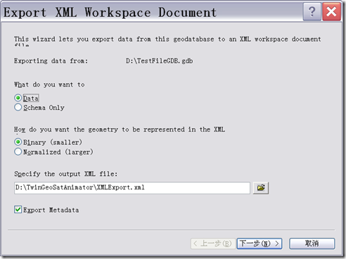
可以选择只将数据库的schema的结构导出,也可以选择将数据也一并导出。到现在的FileGDB API继续沿用这一架构。在FileGDB API中提供了很多
操作Schema内容的函数,如:
操作Domain的函数:
CreateDomain(const std::string &domainDef) //创建域
AlterDomain(const std::string &domainDef) //改变域
DeleteDomain(const std::string &domainDef) //删除域
操作表的函数:
AddField(std::string &fieldDef) //添加字段
AlterField(std::string &fieldDef)//改变字段
DeleteField(std::string &fieldDef)//删除字段
操作子类的函数:
CreateSubtype(std::string &subtypeDef) //创建子类
AlterSubtype(std::string &subtypeDef)//改变子类
DeleteSubtype(std::string &subtypeDef)//删除子类
等等,所有的牵扯到Schema中对象的定义,修改,删除等函数的参数,都是XML格式,当然这些XML格式并不能随便写,必须得按照ESRI的规范
进行书写,具体规范在FileGDB API的doc文件中的XML_Schema_of_Geodatabase-3.pdf中有详细的介绍。以下是常用的几种对象的定义规范:
1. 字段的定义
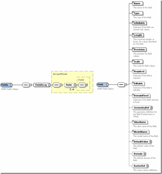
以下是XML表示的Field例子:
<Field xmlns:xsi='http://www.w3.org/2001/XMLSchema-instance' xmlns:xs='http://www.w3.org/2001/XMLSchema'
xmlns:esri='http://www.esri.com/schemas/ArcGIS/10.1' xsi:type='esri:Field'>
<Name>night
Name>
<Type>esriFieldTypeString
Type> <IsNullable>true
IsNullable> <Length>4
Length> <Precision>0
Precision> <Scale>0
Scale> <AliasName>day
AliasName> <ModelName>night
ModelName> <DefaultValue xsi:type="xs:string">afternoon
DefaultValue>
Field>
其中Type元素定义了字段的类型,FileGDB API一共提供了13种数据类型,分别是
esriFieldTypeSmallInteger esriFieldTypeInteger esriFieldTypeSingle esriFieldTypeDouble esriFieldTypeString esriFieldTypeDate esriFieldTypeOID esriFieldTypeGeometry esriFieldTypeBlob esriFieldTypeRaster esriFieldTypeGUID esriFieldTypeGlobalID esriFieldTypeXML
2. 表的定义
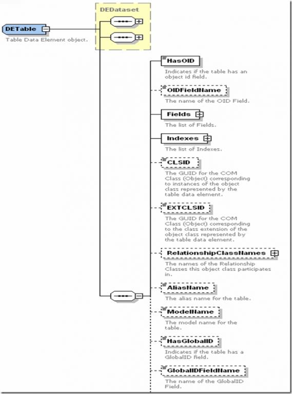
XML例子如下:
xml version="1.0" encoding="UTF-8"?>
<esri:DataElement xmlns:esri='http://www.esri.com/schemas/ArcGIS/10.1'
xmlns:xsi='http://www.w3.org/2001/XMLSchema-instance' xmlns:xs='http://www.w3.org/2001/XMLSchema' xsi:type='esri:DETable'>
<CatalogPath>/StreetInfo
CatalogPath>
<Name>StreetInfo
Name> <MetadataRetrieved>true
MetadataRetrieved> <Metadata xsi:type='esri:XmlPropertySet'> <XmlDoc> <?xml version="1.0"?> <metadata xml:lang="en"><Esri><CreaDate>20101215</CreaDate><CreaTime>13025800</CreaTime><ArcGISFormat>1.0</ArcGISFormat><SyncOnce>TRUE</SyncOnce></Esri></metadata>
XmlDoc>
Metadata> <DatasetType>esriDTTable
DatasetType> <Versioned>false
Versioned> <CanVersion>false
CanVersion> <ConfigurationKeyword>
ConfigurationKeyword> <HasOID>true
HasOID> <OIDFieldName>OBJECTID
OIDFieldName> <Fields xsi:type='esri:Fields'> <FieldArray xsi:type='esri:ArrayOfField'> <Field xsi:type='esri:Field'> <Name>OBJECTID
Name> <Type>esriFieldTypeOID
Type> <IsNullable>false
IsNullable> <Length>4
Length> <Precision>0
Precision> <Scale>0
Scale> <Required>true
Required> <Editable>false
Editable> <DomainFixed>true
DomainFixed> <AliasName>OBJECTID
AliasName> <ModelName>OBJECTID
ModelName>
Field> <Field xsi:type='esri:Field'> <Name>Name
Name> <Type>esriFieldTypeString
Type> <IsNullable>true
IsNullable> <Length>50
Length> <Precision>0
Precision> <Scale>0
Scale> <AliasName>Name
AliasName> <ModelName>Name
ModelName> <DefaultValue xsi:type='xs:string'>
DefaultValue>
Field> <Field xsi:type='esri:Field'> <Name>StreetType
Name> <Type>esriFieldTypeInteger
Type> <IsNullable>true
IsNullable> <Length>4
Length> <Precision>0
Precision> <Scale>0
Scale> <AliasName>StreetType
AliasName> <ModelName>StreetType
ModelName> <DefaultValue xsi:type='xs:double'>1
DefaultValue>
Field> <Field xsi:type='esri:Field'> <Name>Width
Name> <Type>esriFieldTypeDouble
Type> <IsNullable>true
IsNullable> <Length>8
Length> <Precision>0
Precision> <Scale>0
Scale> <AliasName>Width
AliasName> <ModelName>Width
ModelName> <DefaultValue xsi:type='xs:double'>25.0
DefaultValue>
Field> <Field xsi:type='esri:Field'> <Name>LastPaved
Name> <Type>esriFieldTypeDate
Type> <IsNullable>true
IsNullable> <Length>8
Length> <Precision>0
Precision> <Scale>0
Scale> <AliasName>LastPaved
AliasName> <ModelName>LastPaved
ModelName> <DefaultValue xsi:type='xs:dateTime'>2000-01-01T00:00:00
DefaultValue>
Field>
FieldArray>
Fields> <Indexes xsi:type='esri:Indexes'> <IndexArray xsi:type='esri:ArrayOfIndex'> <Index xsi:type='esri:Index'> <Name>FDO_OBJECTID
Name> <IsUnique>true
IsUnique> <IsAscending>true
IsAscending> <Fields xsi:type='esri:Fields'> <FieldArray xsi:type='esri:ArrayOfField'> <Field xsi:type='esri:Field'> <Name>OBJECTID
Name> <Type>esriFieldTypeOID
Type> <IsNullable>false
IsNullable> <Length>4
Length> <Precision>0
Precision> <Scale>0
Scale> <Required>true
Required> <Editable>false
Editable> <DomainFixed>true
DomainFixed> <AliasName>OBJECTID
AliasName> <ModelName>OBJECTID
ModelName>
Field>
FieldArray>
Fields>
Index>
IndexArray>
Indexes> <CLSID>{7A566981-C114-11D2-8A28-006097AFF44E}
CLSID> <EXTCLSID>
EXTCLSID> <RelationshipClassNames xsi:type='esri:Names'>
RelationshipClassNames> <AliasName>TestTable
AliasName> <ModelName>
ModelName> <HasGlobalID>false
HasGlobalID> <GlobalIDFieldName>
GlobalIDFieldName> <RasterFieldName>
RasterFieldName> <ExtensionProperties xsi:type='esri:PropertySet'> <PropertyArray xsi:type='esri:ArrayOfPropertySetProperty'>
PropertyArray>
ExtensionProperties> <ControllerMemberships xsi:type='esri:ArrayOfControllerMembership'>
ControllerMemberships>
esri:DataElement>
3. 索引的定义
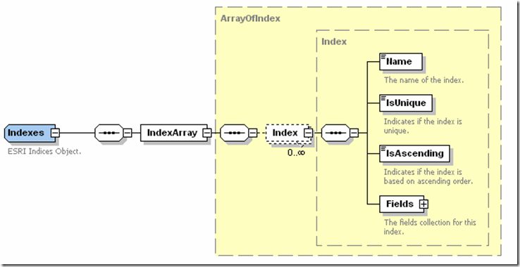
XML例子表示:
<esri:Index xsi:type='esri:Index' xmlns:xsi='http://www.w3.org/2001/XMLSchema-instance'
xmlns:xs='http://www.w3.org/2001/XMLSchema' xmlns:esri='http://www.esri.com/schemas/ArcGIS/10.1'>
<Name>StreetTypeIdx
Name>
<IsUnique>false
IsUnique> <IsAscending>true
IsAscending> <Fields xsi:type='esri:Fields'> <FieldArray xsi:type='esri:ArrayOfField'> <Field xsi:type='esri:Field'> <Name>StreetType
Name> <Type>esriFieldTypeSmallInteger
Type> <IsNullable>false
IsNullable> <Length>2
Length> <Precision>0
Precision> <Scale>0
Scale> <Required>true
Required> <Editable>false
Editable> <DomainFixed>true
DomainFixed> <AliasName>StreetType
AliasName> <ModelName>StreetType
ModelName>
Field>
FieldArray>
Fields>
esri:Index>
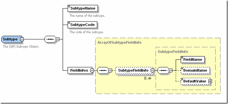
SubType的XML的结构图:
XML的例子:
<esri:Subtype xmlns:xsi="http://www.w3.org/2001/XMLSchema-instance" xmlns:xs=http://www.w3.org/2001/XMLSchema
xmlns:esri="http://www.esri.com/schemas/ArcGIS/10.1" xsi:type="esri:Subtype">
<SubtypeName>subtype three
SubtypeName>
<SubtypeCode>99
SubtypeCode> <FieldInfos xsi:type="esri:ArrayOfSubtypeFieldInfo"> <SubtypeFieldInfo xsi:type="esri:SubtypeFieldInfo"> <FieldName>percentComplete
FieldName> <DomainName>sampleRangeDomain
DomainName> <DefaultValue xsi:type="xs:double">56
DefaultValue>
SubtypeFieldInfo>
FieldInfos>
esri:Subtype>
先举着这些例子吧,居然别的类型,可以查看pdf文件。
文章来源:http://blog.csdn.net/liufeng1980423/article/details/6220693
可以选择只将数据库的schema的结构导出,也可以选择将数据也一并导出。到现在的FileGDB API继续沿用这一架构。在FileGDB API中提供了很多
操作Schema内容的函数,如:
操作Domain的函数:
CreateDomain(const std::string &domainDef) //创建域
AlterDomain(const std::string &domainDef) //改变域
DeleteDomain(const std::string &domainDef) //删除域
操作表的函数:
AddField(std::string &fieldDef) //添加字段
AlterField(std::string &fieldDef)//改变字段
DeleteField(std::string &fieldDef)//删除字段
操作子类的函数:
CreateSubtype(std::string &subtypeDef) //创建子类
AlterSubtype(std::string &subtypeDef)//改变子类
DeleteSubtype(std::string &subtypeDef)//删除子类
等等,所有的牵扯到Schema中对象的定义,修改,删除等函数的参数,都是XML格式,当然这些XML格式并不能随便写,必须得按照ESRI的规范
进行书写,具体规范在FileGDB API的doc文件中的XML_Schema_of_Geodatabase-3.pdf中有详细的介绍。以下是常用的几种对象的定义规范:
1. 字段的定义
以下是XML表示的Field例子:
<Field xmlns:xsi='http://www.w3.org/2001/XMLSchema-instance' xmlns:xs='http://www.w3.org/2001/XMLSchema'
xmlns:esri='http://www.esri.com/schemas/ArcGIS/10.1' xsi:type='esri:Field'>
<Name>night
Name>
<Type>esriFieldTypeString
Type> <IsNullable>true
IsNullable> <Length>4
Length> <Precision>0
Precision> <Scale>0
Scale> <AliasName>day
AliasName> <ModelName>night
ModelName> <DefaultValue xsi:type="xs:string">afternoon
DefaultValue>
Field>
其中Type元素定义了字段的类型,FileGDB API一共提供了13种数据类型,分别是
esriFieldTypeSmallInteger esriFieldTypeInteger esriFieldTypeSingle esriFieldTypeDouble esriFieldTypeString esriFieldTypeDate esriFieldTypeOID esriFieldTypeGeometry esriFieldTypeBlob esriFieldTypeRaster esriFieldTypeGUID esriFieldTypeGlobalID esriFieldTypeXML
2. 表的定义
XML例子如下:
xml version="1.0" encoding="UTF-8"?>
<esri:DataElement xmlns:esri='http://www.esri.com/schemas/ArcGIS/10.1'
xmlns:xsi='http://www.w3.org/2001/XMLSchema-instance' xmlns:xs='http://www.w3.org/2001/XMLSchema' xsi:type='esri:DETable'>
<CatalogPath>/StreetInfo
CatalogPath>
<Name>StreetInfo
Name> <MetadataRetrieved>true
MetadataRetrieved> <Metadata xsi:type='esri:XmlPropertySet'> <XmlDoc> <?xml version="1.0"?> <metadata xml:lang="en"><Esri><CreaDate>20101215</CreaDate><CreaTime>13025800</CreaTime><ArcGISFormat>1.0</ArcGISFormat><SyncOnce>TRUE</SyncOnce></Esri></metadata>
XmlDoc>
Metadata> <DatasetType>esriDTTable
DatasetType> <Versioned>false
Versioned> <CanVersion>false
CanVersion> <ConfigurationKeyword>
ConfigurationKeyword> <HasOID>true
HasOID> <OIDFieldName>OBJECTID
OIDFieldName> <Fields xsi:type='esri:Fields'> <FieldArray xsi:type='esri:ArrayOfField'> <Field xsi:type='esri:Field'> <Name>OBJECTID
Name> <Type>esriFieldTypeOID
Type> <IsNullable>false
IsNullable> <Length>4
Length> <Precision>0
Precision> <Scale>0
Scale> <Required>true
Required> <Editable>false
Editable> <DomainFixed>true
DomainFixed> <AliasName>OBJECTID
AliasName> <ModelName>OBJECTID
ModelName>
Field> <Field xsi:type='esri:Field'> <Name>Name
Name> <Type>esriFieldTypeString
Type> <IsNullable>true
IsNullable> <Length>50
Length> <Precision>0
Precision> <Scale>0
Scale> <AliasName>Name
AliasName> <ModelName>Name
ModelName> <DefaultValue xsi:type='xs:string'>
DefaultValue>
Field> <Field xsi:type='esri:Field'> <Name>StreetType
Name> <Type>esriFieldTypeInteger
Type> <IsNullable>true
IsNullable> <Length>4
Length> <Precision>0
Precision> <Scale>0
Scale> <AliasName>StreetType
AliasName> <ModelName>StreetType
ModelName> <DefaultValue xsi:type='xs:double'>1
DefaultValue>
Field> <Field xsi:type='esri:Field'> <Name>Width
Name> <Type>esriFieldTypeDouble
Type> <IsNullable>true
IsNullable> <Length>8
Length> <Precision>0
Precision> <Scale>0
Scale> <AliasName>Width
AliasName> <ModelName>Width
ModelName> <DefaultValue xsi:type='xs:double'>25.0
DefaultValue>
Field> <Field xsi:type='esri:Field'> <Name>LastPaved
Name> <Type>esriFieldTypeDate
Type> <IsNullable>true
IsNullable> <Length>8
Length> <Precision>0
Precision> <Scale>0
Scale> <AliasName>LastPaved
AliasName> <ModelName>LastPaved
ModelName> <DefaultValue xsi:type='xs:dateTime'>2000-01-01T00:00:00
DefaultValue>
Field>
FieldArray>
Fields> <Indexes xsi:type='esri:Indexes'> <IndexArray xsi:type='esri:ArrayOfIndex'> <Index xsi:type='esri:Index'> <Name>FDO_OBJECTID
Name> <IsUnique>true
IsUnique> <IsAscending>true
IsAscending> <Fields xsi:type='esri:Fields'> <FieldArray xsi:type='esri:ArrayOfField'> <Field xsi:type='esri:Field'> <Name>OBJECTID
Name> <Type>esriFieldTypeOID
Type> <IsNullable>false
IsNullable> <Length>4
Length> <Precision>0
Precision> <Scale>0
Scale> <Required>true
Required> <Editable>false
Editable> <DomainFixed>true
DomainFixed> <AliasName>OBJECTID
AliasName> <ModelName>OBJECTID
ModelName>
Field>
FieldArray>
Fields>
Index>
IndexArray>
Indexes> <CLSID>{7A566981-C114-11D2-8A28-006097AFF44E}
CLSID> <EXTCLSID>
EXTCLSID> <RelationshipClassNames xsi:type='esri:Names'>
RelationshipClassNames> <AliasName>TestTable
AliasName> <ModelName>
ModelName> <HasGlobalID>false
HasGlobalID> <GlobalIDFieldName>
GlobalIDFieldName> <RasterFieldName>
RasterFieldName> <ExtensionProperties xsi:type='esri:PropertySet'> <PropertyArray xsi:type='esri:ArrayOfPropertySetProperty'>
PropertyArray>
ExtensionProperties> <ControllerMemberships xsi:type='esri:ArrayOfControllerMembership'>
ControllerMemberships>
esri:DataElement>
3. 索引的定义
XML例子表示:
<esri:Index xsi:type='esri:Index' xmlns:xsi='http://www.w3.org/2001/XMLSchema-instance'
xmlns:xs='http://www.w3.org/2001/XMLSchema' xmlns:esri='http://www.esri.com/schemas/ArcGIS/10.1'>
<Name>StreetTypeIdx
Name>
<IsUnique>false
IsUnique> <IsAscending>true
IsAscending> <Fields xsi:type='esri:Fields'> <FieldArray xsi:type='esri:ArrayOfField'> <Field xsi:type='esri:Field'> <Name>StreetType
Name> <Type>esriFieldTypeSmallInteger
Type> <IsNullable>false
IsNullable> <Length>2
Length> <Precision>0
Precision> <Scale>0
Scale> <Required>true
Required> <Editable>false
Editable> <DomainFixed>true
DomainFixed> <AliasName>StreetType
AliasName> <ModelName>StreetType
ModelName>
Field>
FieldArray>
Fields>
esri:Index>
SubType的XML的结构图:
XML的例子:
<esri:Subtype xmlns:xsi="http://www.w3.org/2001/XMLSchema-instance" xmlns:xs=http://www.w3.org/2001/XMLSchema
xmlns:esri="http://www.esri.com/schemas/ArcGIS/10.1" xsi:type="esri:Subtype">
<SubtypeName>subtype three
SubtypeName>
<SubtypeCode>99
SubtypeCode> <FieldInfos xsi:type="esri:ArrayOfSubtypeFieldInfo"> <SubtypeFieldInfo xsi:type="esri:SubtypeFieldInfo"> <FieldName>percentComplete
FieldName> <DomainName>sampleRangeDomain
DomainName> <DefaultValue xsi:type="xs:double">56
DefaultValue>
SubtypeFieldInfo>
FieldInfos>
esri:Subtype>
先举着这些例子吧,居然别的类型,可以查看pdf文件。
文章来源:http://blog.csdn.net/liufeng1980423/article/details/6220693
